| Weather pictures & report of September 3-4 2011 |
| Multicell thunderstorms along thermal trough |
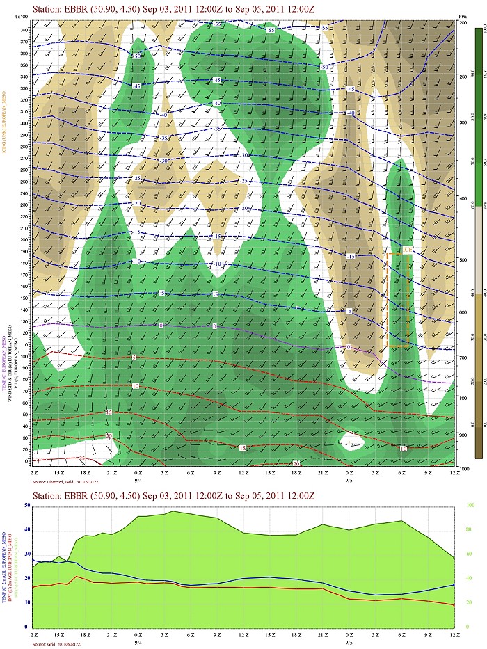
| Synopsis: at 500 hPa: between a relaxing upper trough west of Ireland and a ridge over the continent, our area in a moderate SW'ly flow of warm and humid potentially unstable air. During the late evening - early night passage of a thermal depression with trough releasing the instability in form of some multicell thunderstorms .Very isolated there was some damage due to strong winds or lightning strikes. It gave a nice lightning show at the location were the pictures were made, namely at Steenokkerzeel (central Belgium) with the hours in local time (CET). |
 |
|
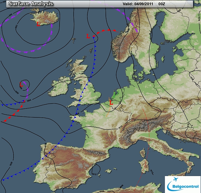
Surface analysis of September 4 2011 at 0200 CET. Related to thermal
depression, a thermal trough crosses the Benelux during the late evening
- early night. (Source chart: Belgocontrol)
|
|
Loop of 8 surface analyses of each hour starting from September 3 at 2200 CET with
weather plots showing the movement of the thermal depression / trough
from southwest to northeast with thundery outbreaks. (Source: meteocentre.com)
|
 |
|
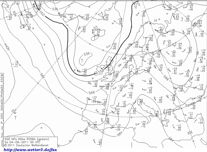
Upper air analysis 500 hPa of September 4 2011 at 0200 CET. Between a
relaxing upper trough west of Ireland and a ridge over the continent our
area in a moderate SW'ly flow. (Source chart: DWD via wetter3)
|
 |
|
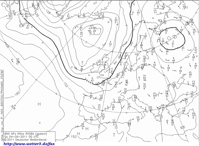
Upper air analysis 850 hPa of September 4 2011 at 0200 CET. Between the
low northwest of Ireland. and anticyclone over eastern Europe, our area in a
moderate S'ly flow of rather warm air. (Source chart: DWD via wetter3)
|
 |
|
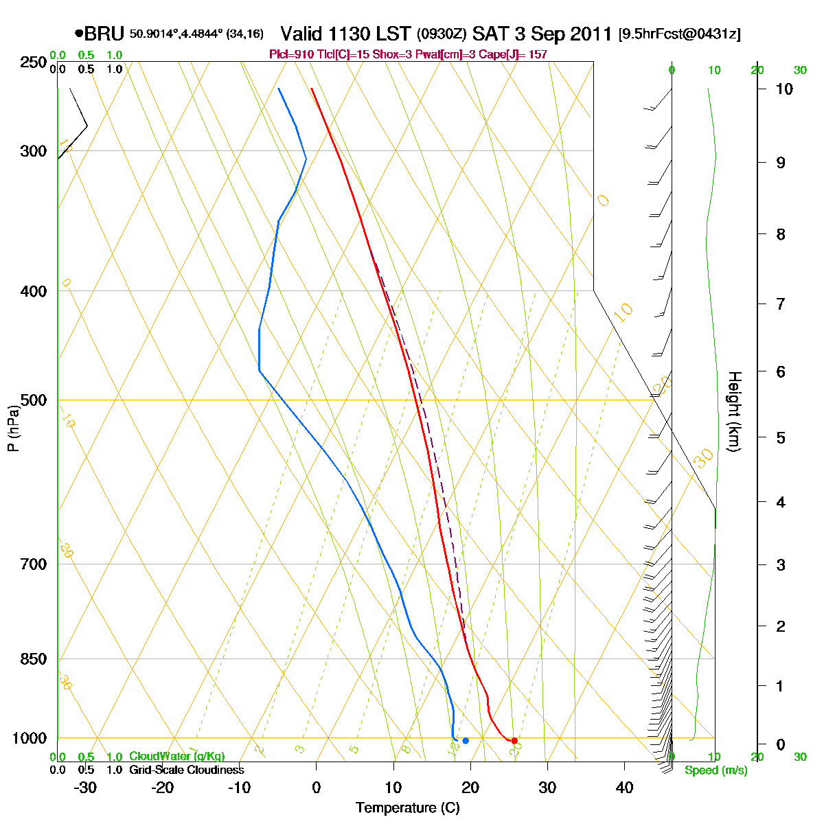
Loop of forecasted soundings for Brussels of September 3 2011 between
1130-2000 CET. During the daylight hours already an unstable airmass but
also too dry to form showers. Directional shear was not very pronounced,
the shear of speed was moderate. (Source: RASP)
|
|
Another loop of forecasted soundings for a 12 hours period (in steps of
three hours) of Brussels from September 3 2011, 2000 CET onwards.
Included are some thunderstorms indices: surface based CAPE was during
the evening still well above 1000 J/kg, dropping fast from midnight
onwards. KI 34, TT 50, LI -6 = moderate convective
potential which may lead to occasional
thunderstorms. Directional shear was weak with around 50 m²/s², low
level shear was 20 kt, deep layer shear 20-30 kt. Due to the
weak to moderate CAPE and moderate deep layer shear, multicells could be expected. (Source: weatheronline.co.uk).
|
 |
|
Forecasted vertical profile and surface temperature for Brussels Airport of September 3 from
1400 CET and the following 48 hours. Legend of upper map: green-brown-white
is humidity in steps of 10% with darkest green being 90% or more, wind
in kt, temperatures each 5°C. At first 6 to 9 hours dry air above 15000
ft, afterwards humid till the
upper levels (200 hPa). Furthermore between 1500-2100 some directional
shear mainly below 2000 ft. A rise in temperature in the lower levels
indicating the passage of thermal trough (in the warmer airmass). Source: Belgocontrol)
|
|
03/09/201 2345-0130 CET. Satellite loop in the infra-red channel.
Multicell thunderstorms moving from Belgium towards Holland while
decaying. (Source sat
picture: Eumetsat via Sat24.com)
|
Radar loop (reflectivity in dBZ) of September 3-4 2011 between 2005-0155 CET. Incoming multicell thunderstorms affecting a large part of Belgium but most active over the center. (Source radar picture: Belgocontrol)
|
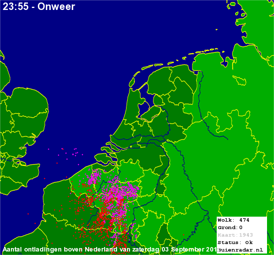 |
Corresponding discharges of September 3 2011 till midnight. (Source lightning picture: Buienradar)
|
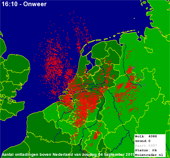 |
Corresponding discharges of September 4 2011 from midnight onwards. (Source lightning picture: Buienradar)
|
 |
|
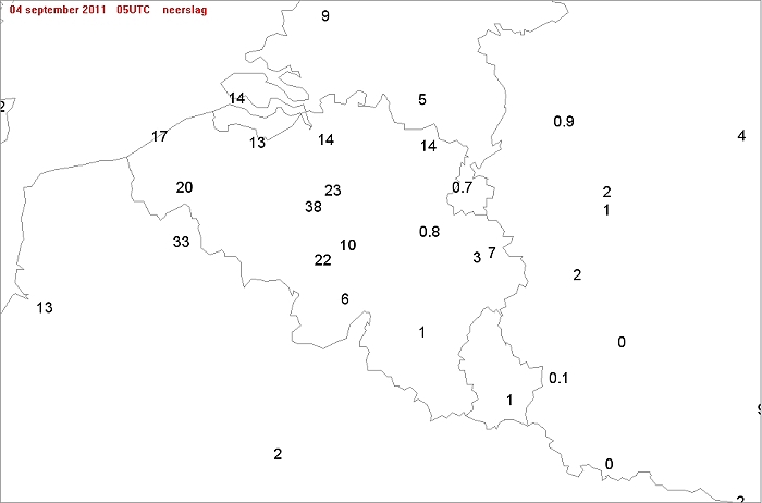
Main theme (besides the amount of lightning strikes) was the rain fall: Ukkel
was the top with 38 mm, followed by Zaventem with 23 mm. My
location at Kampenhout (5 km northeast of Zaventem) received 27 mm.
|
Metars of Brussels Airport (EBBR) (hours in UTC). Translation: copy
paste each obs via
metar-decoder EBBR 032020Z
11003KT CAVOK 23/17 Q1007 TEMPO 2500 TSRA |
 |
|
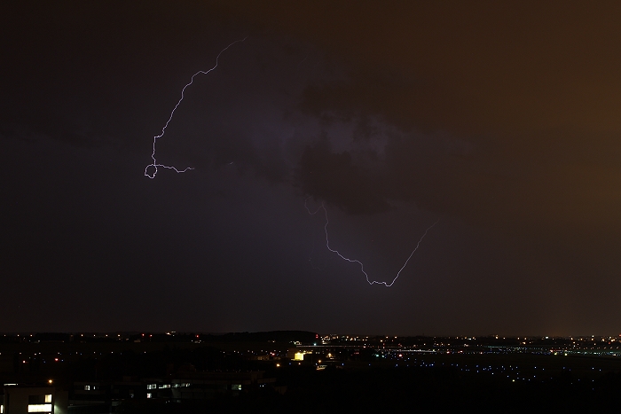
03/09/2011 2309 SW. Cloud-to-air discharge at distance around 18 km (over Watermael-Bosvoorde).
|
 |
|
03/09/2011 2342 SW. Cloud-to-ground discharge at distance around 15 km (over Elsene - Brussels).
|
 |
|
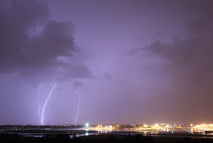
03/09/2011 2343 SW. Triple cloud-to-ground discharge at distance between 12-17 km (over Etterbeek - Ukkel).
|
 |
|
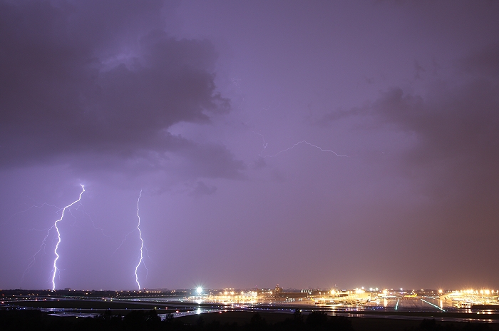
03/09/2011 2344 SW. Double cloud-to-ground discharge at distance around
15 km (over Etterbeek - Ukkel).
|
 |
|
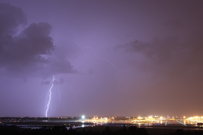
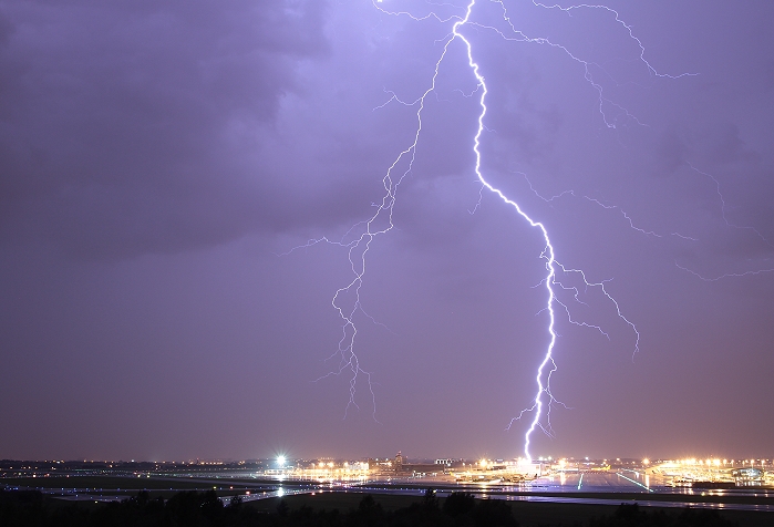
03/09/2011 2346 WSW. Cloud-to-ground discharge at distance around 5 km (Zavenem-Diegem).
|
 |
|
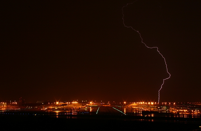
03/09/2011 2351 WSW. Cloud-to-ground discharge at distance around 6 km (over
Vilvoorde).
|
 |
|
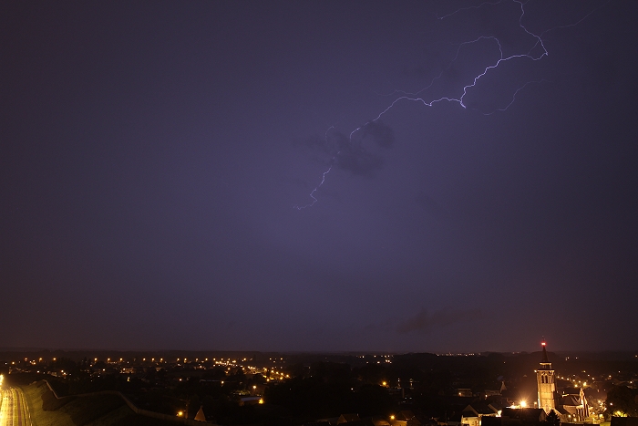
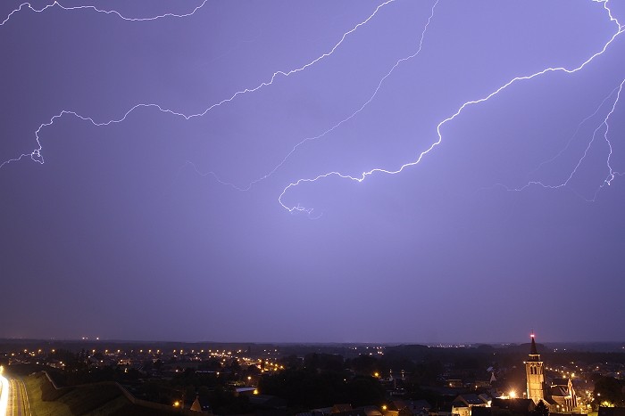
04/09/2011 0039 NE. Cloud-to-air discharge at distance around 20 km (over
Duffel).
|
 |
|
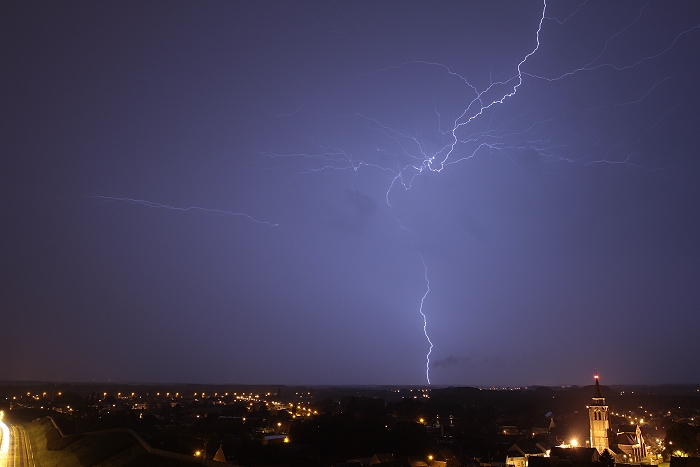
04/09/2011 0041 NE. Cloud-to-ground discharge at distance around 45 km (over
Geel).
|
 |
|
04/09/2011 0044 NE. Cloud-to-air discharge at distance around 16 km (over
Keerbergen).
|