SkyStef's weather page
|
|
SkyStef's weather page |
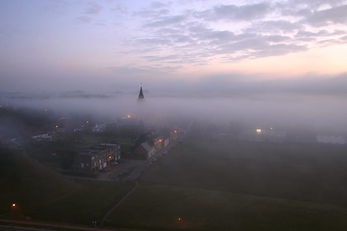
Weather picture of the month November 2008
|
| Picture taken at Steenokkerzeel on October 25 2008 at 0808 hours CET. |
| In general the occurrence of
fog (on flat land) is
usually associated with a cold underlying surface and in this way two
distinct types occur: - radiation fog which is caused by cooling of the ground by nocturnal radiation. - advection fog which is caused by the transport of relatively warm air over a colder surface. The conditions necessary for formation of radiation fog are: sufficiently high dewpoints, sufficient cooling during the night and slight turbulence. (If turbulence is a bit stronger, only low clouds (Stratus) are formed). Advection fogs develop when air moves over a cooler land or sea surface, the surface temperature being below the dewpoint of the moving air. Over land, cooling by radiation frequently intensifies the effects of advection when warm moist air arrives from the sea. This is described as advection-radiation fog. Advection is also responsible for steam fogs: in this case, it is the cold air which is advected over a warm water surface as this water evaporates into the air. Both are grouped as air-mass fogs. By contrast a frontal fog arises from the interaction of two air masses. This may occur in two ways: when a cloud extend to the ground (often over hills), or when the air becomes saturated by continuous rain. Latter conditions are likely to develop in the cold air ahead of a warm front. The picture shows an advection fog, more precisely an advection-radiation fog. Over the southern part of Belgium, a rather huge fog area was formed due to night cooling (radiation fog). Winds blew weak from the SSE and over the affected area some radiation fog patches were already present, but a bit later a wall of fog was advected giving very poor visibilities for about one hour. |